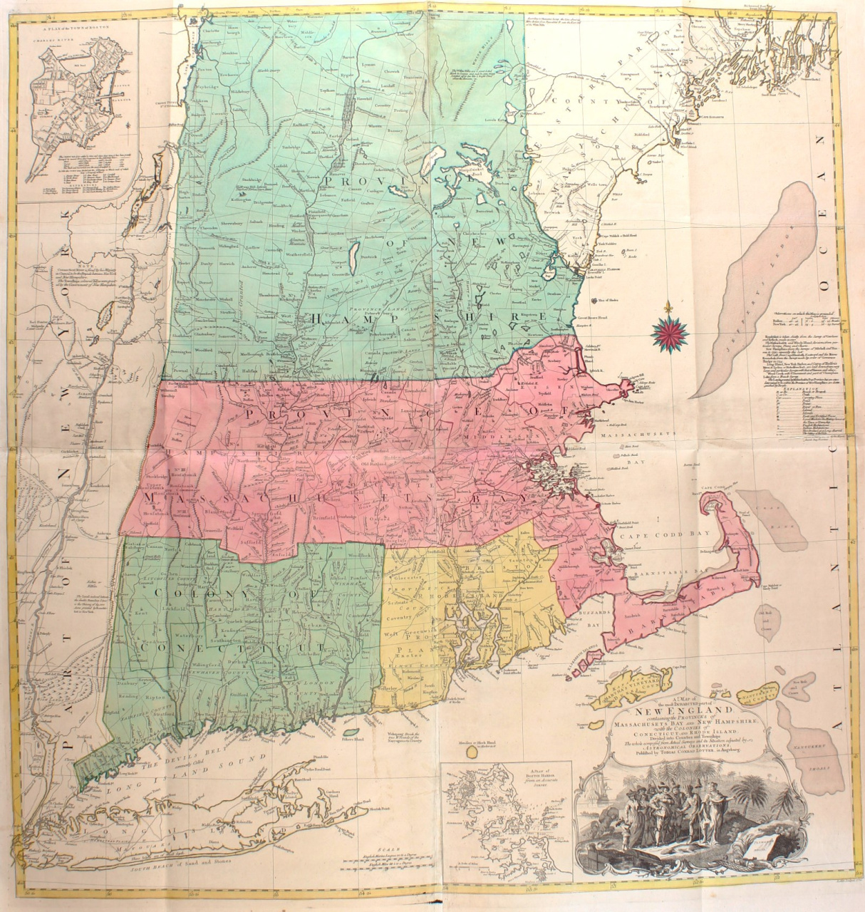
THE MOST IMPORTANT AND INFLUENTIAL MAP OF NEW ENGLAND PUBLISHED DURING THE BRITISH COLONIAL PERIOD "A Map Of The Most Inhabited Part Of New England Containing The Provinces Of Massachusets Bay and New Hampshire. With the Colonies of Conecticut and Rhode Island." Copper engraving in four joined sheets, published by Tobias Lotter of Augsburg in 1776. With original hand colouring. Size: 97,5 x 101,7 cm. Fine example of the large format map of New England and Long Island by the 18th century cartographer Bradock Mead (aka John Green). Bradock Mead's map of New England is generally considered the single most important and influential map of New England published during the British Colonial period. Its importance was such that it was revised and reissued well into the 1790s, and over this period it served as a primary source for leading European and American mapmakers. First issued in 1755, the map provided the largest-scale and most detailed and accurate portrait of the region to date. The map was significantly revised in the 1760s, including a complete re-engraving of much of northern New England and New York and addition of the inset map of Boston. These changes are so extensive that the map, viewed in its proper context, needs to be viewed for historical purposes as a new map. The changes included major improvements to the natural geography of the region (changes to the New Hampshire Lakes Region are particularly striking) , the introduction of settlements in central and northern New Hampshire, and the division of Vermont into dozens of "Wentworth Grant" towns. The map depicts New England to 44°30' North as well as Long Island and the Hudson River Valley. Township, county and provincial boundaries are shown, as are roads, forts, and meetinghouses. Rivers and streams are depicted with relative care, while the many mountain ranges are indicated haphazardly with archaic "molehill" symbols. The contrast between southern and northern New England is striking: Connecticut, Rhode Island and Massachusetts east of the Connecticut River are entirely laid out in a grid of counties and townships; whereas much of New Hampshire and almost all of Vermont are denominated "Wildernes [sic] lands of the crown not yet appropriated." Further, the geography of the north country is but poorly understood, as evidenced by the sketchy detail and distended outlines of New Hampshire's Lakes Region. Present-day Vermont is shown under the aegis of New Hampshire, though the ambiguity of its status at the time is indicated by the absence of a border with New York. Adding to the informational value and decorative appeal of the map are an early chart of Boston Harbor at bottom center, an inset plan of Fort Frederik at upper left, and a decorative cartouche portarying an idealized version of the Pilgrims' landing at Plymouth. A table of notes at the right lists Mead's sources for the map, and in doing so makes clear how much care and effort went into its compilation. Price: Euro6.850,-


![European hunting party] by Unknown artist](https://media-2.gallerease.com/images/cb8cbebf-7709-4817-9bdb-fef8ae1e93cf/350x350/european-hunting-party.jpg)