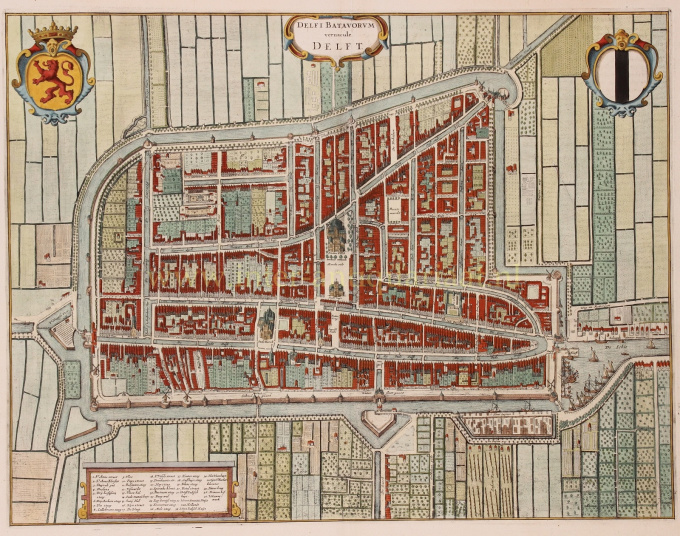
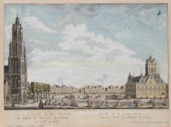
The city of Delft in 1649 1649
Joan Blaeu
TintePapierDruck
48 ⨯ 57 cm
€ 1.850
Inter-Antiquariaat Mefferdt & De Jonge
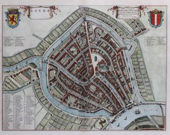
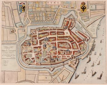
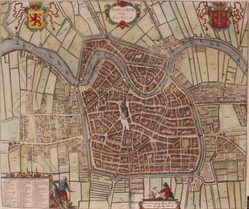
- Über KunstwerkTHE CITY OF DELFT "Delfi Batavorum vernacule Delft", copper engraving, published in Amsterdam by Joan Blaeu in 1649. Size (print) 37,7 x 48,5 cm. Coloured by a later hand. Verso: Latin description of Delft. Until the 17th century, Delft was one of the major cities of Holland. Already in 1400, the city had 6500 inhabitants and was the third largest in size, after Dordrecht (8000) and Haarlem (7000). In 1560 Amsterdam with 28,000 inhabitants had become the largest city, followed by Delft, Leiden and Haarlem, each of which had about 14,000 inhabitants. In the 17th century, Delft experienced a new heyday. A Chamber of the VOC was established in Delft. The city sent a fleet to Southeast Asia three times a year, importing spices, Chinese porcelain and other luxury goods. The tradition of Delftware originated from the import of Chinese porcelain, with an extensive pottery industry. During the Eighty Years' War, Delft became a center of resistance against the Spanish, after several cities and territories managed to evade Spanish authority in the 1570s. Prince William of Orange briefly resided in Delft, in the former Sint-Agatha monastery, which has since been called Prinsenhof. After William of Orange was declared an outlaw by King Philip II, he was also murdered there by Balthasar Gerards in 1584. William of Orange is buried in the Nieuwe Kerk, clearly visible on the map on the market square. After William of Orange, 45 members of the House of Orange and the House of Orange-Nassau were buried in the royal crypt. This map was published after the Peace of Münster (1648) as part of Joan Blaeu's town book of the Netherlands "Novum Ac Magnum Theatrum Urbium Belgicae Liberae Ac Foederatae". The Amsterdam cartographer and publisher Joan Blaeu set himself the task of simultaneously achieving the objectives of Abraham Ortelius (famous for the publication of the first modern atlas in 1578) and Georg Braun and Franz Hogenberg (known for their town book published at the end of 1600): a multi-volume world atlas added by a number of town books. The town book of the United Netherlands was published in a Latin edition in 1649; the Dutch edition was printed in 1652. Some of the maps included in this work had already been published in older maps, other maps were made entirely new for Blaeu's town book. Price: Euro 1.850,-
- Über Künstler
Joan Blaeu (1596-1673), wurde am 23. September 1596 in Alkmaar geboren.
Er war ein niederländischer Kartograph, der in Alkmaar geboren wurde. Er trat in die Fußstapfen seines Vaters, des Kartografen Willem Blaeu.
1620 wurde er promovierter Jurist, trat aber in das Werk seines Vaters ein. 1635 veröffentlichten sie den Atlas Novus (vollständiger Titel: Theatrum orbis terrarum, sive, Atlas novus) in zwei Bänden. Joan und sein Bruder Cornelius übernahmen das Atelier nach dem Tod ihres Vaters im Jahr 1638. Joan wurde der offizielle Kartograf der Niederländischen Ostindien-Kompanie.
Blaeus Weltkarte Nova et Accuratissima Terrarum Orbis Tabula, die die Entdeckungen von Abel Tasman enthält, wurde 1648 veröffentlicht. Diese Karte war insofern revolutionär, als sie „das Sonnensystem gemäß den heliozentrischen Theorien von Nicolaus Copernicus darstellt, die zeigen, dass sich die Erde um sie dreht die Sonne .... Obwohl Kopernikus' bahnbrechendes Buch "Über die Revolutionen der Sphären" erstmals 1543 gedruckt wurde, war Blaeu etwas mehr als ein Jahrhundert zuvor der erste Kartograph, der diese revolutionäre heliozentrische Theorie in eine Weltkarte einfließen ließ."
Blaeus Karte wurde für die Weltkarte kopiert, die 1655 in das Pflaster des Groote Burger-Zaal des neuen Amsterdamer Rathauses eingelassen wurde, das vom niederländischen Architekten Jacob van Campen (heute Amsterdamer Königspalast) entworfen wurde.
Blaeus Hollandia Nova wurde auch in seinem 1659 erschienenen Archipelagus Orientalis sive Asiaticus im Kurfürsten-Atlas (Atlas des Großen Kurfürsten) abgebildet. und von Melchisédech Thévenot zur Erstellung seiner Karte Hollandia Nova – Terre Australe (1664) verwendet.
Als „Jean Blaeu“ veröffentlichte er auch den 12-bändigen „Le Grand Atlas, ou Cosmographie blaviane, en laquelle est Exactement descritte la terre, la mer, et le ciel“. Eine Ausgabe ist auf 1663 datiert. Das war Folio (540 x 340 mm) und enthielt 593 gestochene Karten und Tafeln. Im März 2015 wurde eine Kopie für 750.000 £ verkauft.
Um 1649 veröffentlichte Joan Blaeu eine Sammlung niederländischer Stadtpläne mit dem Titel Toonneel der Steeden (Ansichten von Städten). 1651 wurde er in den Amsterdamer Rat gewählt. 1654 veröffentlichte Joan den ersten schottischen Atlas, der von Timothy Pont entworfen wurde. 1662 gab er den Atlas Novus, auch bekannt als Atlas Maior, in 11 Bänden und einem für Ozeane neu heraus.
Als nächstes Projekt war eine Kosmologie geplant, doch 1672 zerstörte ein Brand das Atelier vollständig.
Joan Blaeu starb im folgenden Jahr, 1673, in Amsterdam. Er wurde in der Westerkerk in Amsterdam begraben.
Sind Sie daran interessiert, dieses Kunstwerk zu kaufen?
Artwork details
Related artworks
- 1 - 4 / 12
Cornelis Anthonisz Theunissen
MUY RARO PRIMER MAPA IMPRESO DE ÁMSTERDAM, UNA CIUDAD EN ASCENSO1544
€ 175.000Inter-Antiquariaat Mefferdt & De Jonge
 curada por
Danny Bree
1 - 4 / 24Samuel Dejong
Anatomia Blue Heritage, Goliath Beetle Closed2020
Precio a consultarVilla del Arte Galleries
Jean-François Rauzier
Amsterdam Centraal - Limited edition of 8 2015
Precio a consultarVilla del Arte Galleries
Samuel Dejong
Anatomia Blue heritage II Goliath Beetle closed BGG2019
Precio a consultarVilla del Arte Galleries
Samuel Dejong
Anatomia Blue Heritage, Hercules Beetle Open2020
Precio a consultarVilla del Arte Galleries
Samuel Dejong
Anatomia Blue Heritage, Goliath Beetle Open2020
Precio a consultarVilla del Arte Galleries
Antonie Derkinderen
Memory book Exhibition of Dutch Painting1892
Precio a consultarKunsthandel Pygmalion
1 - 4 / 24Gerrit Willem Dijsselhof
Certificate of the Association of Booksellers1886 - 1924
Precio a consultarKunsthandel Pygmalion
1 - 4 / 24- 1 - 4 / 12

