North Holland - Johannes Dou, 1729 by Johannes Dou
Scroll to zoom, click for slideshow

North Holland - Johannes Dou, 1729 1729

Johannes Dou

PaperPrint
86 ⨯ 112 cm
€ 3.250

Inter-Antiquariaat Mefferdt & De Jonge

  • About the artwork
    WALL MAP OF NORTH HOLLAND “’T Hoogheemraadschap vande Uytwaterende Sluysen in Kennemerlant ende West-Frieslant” [The Hoogheemraadschap (water board) of Uitwaterende Sluizen in Kennemerland and West Friesland], copper engraving after the design of Johannes Dou I, published in Amsterdam by Andries and Hendrik de Leth in 1729. Coloured by a later hand. Four sheets joined. Size: 86 × 112 cm. This map is a characteristic example of Dutch water management cartography. To protect the low-lying Holland polderland — situated in a deep basin — from the waters of the sea and rivers, a large number of waterschappen (water boards) were established throughout western Netherlands, each responsible for hydraulic works and flood protection within its district. For efficient water management, accurate overview maps were of vital importance. The Dijkgraaf (dike reeve) and High Heemraden (board members) of the water board of the Uitwaterende Sluizen in Kennemerland and West Friesland commissioned the surveyor and mapmaker Johannes Dou I (1615–1682) to chart their jurisdiction in the northern part of Holland. Dou spent an astonishing twenty years on the project, completing in 1682 an enormous map composed of sixteen sheets. Two years later, a reduced version on four sheets was produced, as well as a smaller single-sheet edition. All three versions of the map were engraved by Koenraet Decker (1651–1709), a pupil of Romeyn de Hooghe and Abraham Deur. Although their names appear only on the sixteen-sheet edition, it has been shown that the copperplates were reused and copied multiple times, both individually and in sets of three maps. While the cartographic content remained unchanged, small variations can be found in the coats of arms of the water board officials. Based on the heraldry on this particular copy — those of Dijkgraaf Aris van der Mienden, and Hoogheemraden Gijsbert Ramp, Claas Swaan, Cornelis van Eyck, Adriaan Warmenhuisen, and Rentmeester en Secretaris (land agent and secretary) Johan Baert — we can date this example to 1729. Johannes Dou I was admitted as a land surveyor by the Hof van Holland (High Court of Holland) on 10 September 1635. He studied at the University of Leiden, and after his father’s death in 1635 he was appointed, together with Steven van Broeckhuysen, as permanent surveyor of the Hoogheemraadschap van Rijnland. From 1637 onwards he also practised as a notary public. Literature: o.a. Donkersloot - de Vrij, Topografische kaarten van Nederland vóór 1750, p. 147-148, no. 751. Price: Euro 3.250,-
  • About the artist

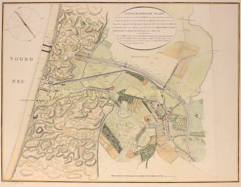
    Johannes Dou, also known as Jan Jansz., or Douw (Leiden, February 7, 1615 - March 5, 1682) was a land surveyor who mainly worked for the Rijnland Water Board.

    Johannes Dou was born in Leiden in 1615 (according to his father on 7 February) as the son of Jan Pieterszoon Dou and Josina Sadelaer. On March 8, 1634, Johannes was enrolled at Leiden University as a student of mathematics.

    He attended lectures with Frans van Schoten sr., professor of 'Duytsche mathematicque', the training for engineers, fortress builders and land surveyors. His father was a prominent land surveyor with a large production, who also published several books about his field.

    He probably taught his son what he needed in practice. In any case, on September 10, 1635, Johannes was admitted by the Court of Holland to practice the profession of land surveyor. In 1637 he was appointed notary.

    After the death of his father in 1635, Dou was appointed together with Steven van Broeckhuizen as land surveyor of Rijnland and from 1637 also appears as a notary in Leiden. Like his father, he was extremely productive, but never attained his scientific stature.

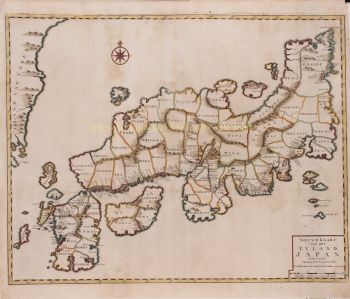
    In addition to many small commissions, he also distinguished himself with some more tasteful works. For example, in 1661 he designed the canal from Leiden to Utrecht, he was deployed in 1672 during the campaign against the French and in 1675 he completed his large map of the Uitwaterende Sluizen.

Are you interested in buying this artwork?

Artwork details

Category
Subject
Style
Material & Technique