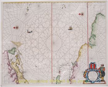
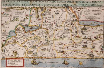
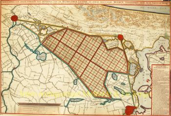
RICHLY DECORATED EARLY MAP OF HOLLAND "Hollandia", copper engraving published by Willem Jansz. Blaeu "Inde vergulde Sonnewyser" [in the gilded sundial] in Amsterdam, first in 1604, here in the 2nd state (of 5) from 1604-1607. Coloured by a later (?) hand. Size: 41 x 56.3 cm. The map states in Latin and Dutch that is a "New description of the County of Holland with all its cities, villages, and castles, as well as all the waters and rivers included therein, as well as the sea channels and gats such as the Maas, Marsdiep, 't Vlie, Texel, and Vliestroom, with all its sandbanks, shoals, dry areas, buoys, beacons, depths, and shallows, all newly improved with accurate directions." It stands out for its rich decoration. It is the oldest (!) Dutch map featuring town views. At the top, we see Amsterdam, Dordrecht, the Court of Holland in The Hague, Leiden, and Rotterdam with their respective coats of arms. At the bottom, Enkhuizen, Gouda, Delft, Haarlem, Alkmaar, and Hoorn, also with coats of arms. On the left and right, the coats of arms of other cities in Holland are displayed. The map is not the result of new mapping, but rather a compilation of several printed maps and charts. In depicting the land, particular use was made of two maps which rely partly on the mapping done by cartographer Jacob van Deventer: a 1569 wall map of Holland and Utrecht by Nicolaus Liefrincx (of which of the last know copy was lost in 1945), and Van den Keere's 1596 map of Holland in folio size. The map of Antwerp publisher Abraham Ortelius from 1570 is also largely followed. The northern part of North Holland, the rounded shape of Wieringen, Eijerland separated from Texel, and the shallows and navigation channels in the Wadden Sea and Zuiderzee follow a map brought to market around 1590 by Lucas Jansz. Waghenaer. Blaeu also adopted the depth measurements in the channels and the buoyage. By giving his map an orientation different from these examples, Willem Jansz may have wanted to give the impression of having published a new map of Holland, based on recent surveys New is the depiction of the Schermer polder, which has been given an angular shape, and between the Schermer and the IJ, some waterways are indicated that do not appear on earlier maps. Truly innovative, however, is the depiction further north, where the Zijpe polder, which was flooded in 1570 and reclaimed in 1597, is shown by Blaeu with new parceling. This is also mentioned (in Latin): "The Zijpe has been reclaimed after being submerged for 27 years due to a sea flood. Now there are once again inhabitants cultivating it." Regarding the Roman fort Brittenburg, the map states: "Here was once the mouth of the Rhine, as well as Brittenburg, which was observed by many in the years 1520, 1552, 1562, 1571, and 1588, and from which many ancient finds have been excavated." It must have left a significant impression on people how a Roman fort would suddenly emerge from the sea every few years. Several maps from that time make note of it. Both the verso and recto of this map bear seventeenth-century ownership and price annotations, including amounts of 8 and 10 stuivers. A note dated 8 April 1648 indicates that the map continued to be traded several decades after its original publication. Literature: Blonk (2000) "Hollandia Comitatus - een cartobibliografie van Holland", map no. 30.2 Schilder (2000) "Monumenta Cartographica Neerlandica", vol. VI, map no. 68.2 Price: Euro 4.950,-