Antique map of South East Asia - Johannes Janssonius 1630
Johannes Janssonius
Carta
39 ⨯ 50 cm
€ 1.850
Inter-Antiquariaat Mefferdt & De Jonge
- A proposito di opere d'arteA LANDMARK EARLY MAP OF SOUTHEAST ASIA, THE PHILIPPINES, AND AUSTRALIA “Indiae Orientalis Nova Descriptio.“ Copper engraving published by Johannes Janssonius (in English also known as Jan Jansson) in 1630. With original hand colouring. Size (plate mark): 39 x 50,7 cm. This edition of Johannes Janssonius’ map—first appearing in his “Appendix” in 1630—is celebrated for its excellent regional detail and its historical significance. It is notably the only Dutch printed map to record the 1606 discoveries of captain Willem Janszoon aboard the Duyfken, an expedition that led to the first recorded European landing on Australian soil, specifically on the west coast of Cape York Peninsula. In the early 17th century, the Dutch East India Company (VOC) was eager to expand its trade monopoly in the East Indies. In 1605, at the initiative of the VOC, Jan Willemsz Verschoor organized an expedition "to discover the great land of New Guinea and other eastern and southern lands." Willem Janszoon (1570-1636) was selected for this pioneering expedition, setting sail from Bantam (Indonesia) in late 1605. According to John Saris, an agent for the British East India Company, the Duyfken departed on November 28, 1605. In early 1606, after navigating New Guinea’s south coast, Jansz sailed south across Torres Strait—mistaking it for a shallow bay—and continued along what he presumed was the continuation of New Guinea’s coastline. In truth, he was venturing into the waters off the Australian coast. Unbeknownst to him, this voyage marked the first recorded European encounter with Australian soil. In addition, the map also presents the Philippines in detail for the first time. Janssonius drew upon the work of VOC cartographer Hessel Gerritsz, utilizing information that the VOC had strictly controlled in the early 17th century for competitive reasons. Janssonius’ map is significant not only for its depiction of the discoveries in New Guinea, referred to as “Duyfkens Eylant,” but also as the sole printed cartographic record of part of the Duyfken’s route until later maps emerged. While the map uses a scale of miles to cover the area of the Australian discoveries—thus offering less detail on Jansz’s Australian findings—it remains an invaluable document in the history of European exploration in the region. Price: Euro 1.850,- (incl. frame)
- A proposito di opere artista
Janssonius è nato ad Arnhem come figlio di Jan Jansz, tipografo ed editore locale. In giovane età si trasferì ad Amsterdam, l'allora centro della stampa e del commercio di carte. Nel 1612 sposò Elisabeth Hondius, figlia di Jodocus Hondius. Elisabeth morì nel 1627 e Janssonius si risposò nel 1629 con Elisabeth Carlier. Andò a lavorare per suo suocero e continuò l'attività editoriale insieme a Henricus Hondius (figlio di) dopo la sua morte. Questo è stato sviluppato in uno dei più grandi del suo tempo. C'erano filiali a Berlino, Francoforte, Ginevra, Lione e Stoccolma, tra gli altri.
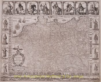
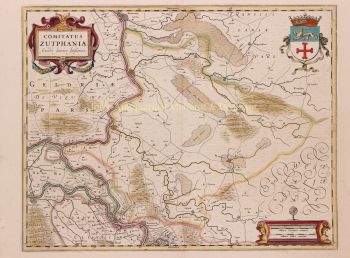
Sotto la guida di Janssonius, il Mercator-Hondius Atlas fu ampliato e pubblicato come Atlas Novus. Questa edizione inizialmente monovolume si trasformò ben presto in un atlante in più volumi, integrato su richiesta con carte nautiche e/o carte celesti. C'erano pubblicazioni in olandese, francese, spagnolo e latino. Come i suoi contemporanei, anche Janssonius fece uso di lastre di rame esistenti, tra cui quelle dei libri cittadini di Braun & Hogenberg e la Description de touts les Pays Bas (Descrizione di tutti i Paesi Bassi) di Lodovico Guicciardini - (edizione Cornelis Claesz.) da 1609 Sebbene Janssonius sia stato spesso accusato di aver copiato il lavoro di Willem Blaeu, si può notare che anche le mappe di Janssonius sono apparse sul mercato prima.
Dopo la morte di Janssonius, l'azienda fu portata avanti da suo genero, Johannes (Jan) van Waesbergen, che sposò sua figlia Elisabeth Janssonius (1615-1681). Molte lastre di rame dei libri cittadini furono utilizzate (a volte leggermente modificate) da Frederik de Wit. L'edificio in piazza Dam è stato affittato a Gerard Valck; Ha anche acquistato una serie di lastre da stampa nel 1694.
Sei interessato ad acquistare questa opera d'arte?
Artwork details
Related artworks
- 1 - 4 / 6
Artista Sconosciuto
Een Gotische zuidelijke Nederlanden wandklok1580 - 1590
Prezzo su richiestaNico van den Assem restauratie
1 - 4 / 24- 1 - 4 / 24
- 1 - 4 / 24
- 1 - 4 / 24
- 1 - 4 / 12


