Antique map of West Friesland 1730
Hendrik Leth
Carta
91 ⨯ 109 cm
€ 2.350
Inter-Antiquariaat Mefferdt & De Jonge
- A proposito di opere d'arte“Nieuwe Caarte van het Dykgraafschap van West-Friesland genaamt Geestmer-Ambagt, Schager en Niedorper Cogge” [“New map of the dyke district of West Friesland, called Geestmerambacht, Schagerkogge and Niedorperkogge.] Copper engraving drawn by cartographer Pieter Straat and engraved by Hendrik de Leth in Amsterdam, circa 1730. With beautiful original hand-colouring. Four joined sheets, together measuring 91 x 109 cm. In the Middle Ages, West Friesland was divided into four ambachten (districts). These were supra-local administrative units that likely existed even before West Friesland was brought under control by the Counts of Holland. Each ambacht in turn consisted of several coggen, which were further subdivided into bannen (villages or polders without a specific central village). This hydrographic map shows the three historical water boards: Geestmerambacht, Schagerkogge, and Niedorperkogge, which together formed the western part of old West Friesland. (In the eastern part of West Friesland were the ambachten of the Four Northern Coggen and Drechterland.) The cartouches on the map display the coats of arms of various villages located in the ambacht. On the left is the coat of arms of Geestmerambacht. In the center are the arms of Schagerkogge (Schagen, Barsingerhorn, and Obdam). On the right, finally, is the coat of arms of the dyke board of the Niedorperkogge, combining the arms of Nieuwe Niedorp (top), Winkel (lower left), and Oude Niedorp (lower right). A century before this map was made, a long-running legal battle played out between eastern and western West Friesland. The dispute concerned the apportionment of maintenance costs for the Westfriese Omringdijk, the great ring dyke protecting the entire region from the sea. The cost-sharing formula dated back to the 14th century and had become outdated. In the 17th century, following the reclamation of areas such as the Heerhugowaard, Schermermeer, Zijpe, and Wieringerwaard, the dyke in the western part of West Friesland was no longer directly exposed to the sea. As a result, maintenance costs there dropped significantly. Eastern West Friesland, however, continued to face the constant threat of the Zuiderzee. The eastern side demanded a revised cost allocation, arguing that a breach in the eastern dyke would also flood the western part. In 1637, eastern West Friesland brought the case before the High Council in The Hague. The lawsuit dragged on until 1695 and became known as the "Great Process" (Groot Proces). This situation is clearly illustrated on the map: the Westfirese Omringdijk is now surrounded by reclaimed land, and the seaward protection it once provided has diminished. The map also presents a finely detailed network of polders, ditches, canals, and dykes, complete with parcel indicators, field divisions, toponyms, and waterways. In several plots, letters and numbers appear - likely references to ownership or land use. The polder landscape reveals a carefully organized division of farmland, dyke routes, and buildings, a depiction vital to managing the vulnerable peat and clay soils. In the lower right corner, an large idyllic landscape scene has been added, with cheese production as its theme. A seated man rests atop a stack of cheeses, overlooking a classic polder view. In the 18th century, the peat polders of West Friesland developed into key areas for dairy farming, with cattle grazing on the soggy meadows. The milk produced was processed into Gouda-style (like Beemster) and Edam cheeses, which were traded and exported via local markets in places like Schagen, Hoorn, and especially Alkmaar. By the 18th century, Alkmaar had become a major hub for cheese trading, bolstered by its weekly cheese market where produce from the entire region was brought in. Small farming operations benefited from the area's navigable waterways, which allowed them to transport their goods quickly and efficiently. Thus, the watery landscape and peat meadows were essential to the region’s cheese trade and broader economy. Price: Euro 2.350,-
- A proposito di opere artista
Hendrik de Leth (Amsterdam, 31 maggio 1703 – Amsterdam, 17 giugno 1766) è stato un artista della stampa, incisore, incisore, cartografo, disegnatore, libraio, mercante d'arte, editore di stampe, collezionista d'arte e collezionista di naturalia.
Hendrik de Leth era figlio di Andries de Leth (tagliapiatti, libraio, 1662-1731) e Nelletje Middenheespen. Hendrik aveva un fratello maggiore, Christiaan de Leth. Nel 1742 Hendrik sposò Sophia Otto, che morì nel 1753. Il loro matrimonio rimase senza figli. Era probabile che il nipote Andries, figlio del fratello di Hendrik, Christiaan, sarebbe diventato il successore dell'attività di Hendrik. Tuttavia, morì nel 1743. Nel 1766 Hendrik de Leth fece redigere un testamento poco prima della sua morte, in base al quale Catharina le Blanc, nipote del fratello Christiaan, divenne erede. Il 30 settembre 1766 ebbe luogo l'asta dei suoi beni.[3]
Nel 1728 Hendrik si unì alla corporazione dei librai. Prima di allora era uno studente di suo padre Andries de Leth, che aveva rilevato la mappa, la stampa e il mercante d'arte "Op de Beurssluys, in den Visscher" ad Amsterdam dal cartografo e incisore Nicolaas Visscher II. Hendrik de Leth a sua volta rilevò questa azienda dopo la morte del padre nel 1731.
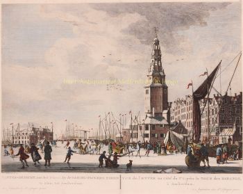
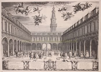
Già nel 1725 fu pubblicata l'opera Images of the Wijdtvermaarde city of Amsterdam oltre ai suoi più importanti Buildings and Gesites, tutti accuratamente disegnati dopo la vita e pubblicati ad Amsterdam.
La sua opera più nota con 100 stampe fu pubblicata nel 1730: Lo splendore benedicente Kennemerlant : mostra molti volti gloriosi dei luoghi di piacere più importanti di quest'ultimo, case nobiliari, edifici di villaggi e città : a partire da Kastrikum (...) / disegnato dopo la vita e nel rame portato da H. de Leth; e brevemente descritto da M. Brouërius van Nidek. - Amsterdam : De Leth, 1730. Molte stampe che De Leth fece di Amsterdam si trovano negli archivi della città di Amsterdam.
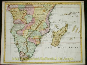
Come cartografo, De Leth era meglio conosciuto per il suo New Geographical Atlas e Historical Atlas, Van de Zeven Vereenigde Nederlandsche Provintien, pubblicato nel 1740. De Leth divenne noto anche per le incisioni su rame che fece intorno al 1758 della Mappa Generale della Colonia o Provincia del Suriname su disegno di Alexander de Lavaux.
Sei interessato ad acquistare questa opera d'arte?
Artwork details
Related artworks
Artista Sconosciuto
Portrait of an Ottoman Elite Woman, Venetian School, 17th Century, 130.2 x 98.9 cm1670 - 1690
Prezzo su richiestaSpectandum Gallery
Artista Sconosciuto
Een Gotische zuidelijke Nederlanden wandklok1580 - 1590
Prezzo su richiestaNico van den Assem restauratie
Artista Sconosciuto
Baroque Iberian Emerald Earrings, 18th Century Goldwork with 58 Emeralds1750
€ 7.250Adin Fine Antique Jewellery
A cura diDanny Bree
1 - 4 / 24- 1 - 4 / 24
Jan Toorop
Narcissus Poeticus met kinderen van Van Schendel uit Ede1919
Prezzo su richiestaStudio 2000 Art Gallery
Jan Sluijters
Greet met Jantje, Moeder met kind, naakt op een stoel staand1900 - 1940
Prezzo su richiestaStudio 2000 Art Gallery
1 - 4 / 24- 1 - 4 / 12


![RARE ARMORIAL MAP: LEO BRABANTIAE Lion of the most noble Duchy of Brabant] by Sibertus Waterloos](https://media-3.gallerease.com/images/325cc033-a3b6-495f-9da8-6d06caf29b14/350x350/rare-armorial-map-leo-brabantiae-lion-of-the-most-noble-duchy-of-brabant.jpg)


