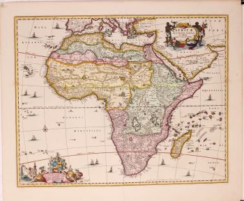
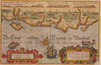
KENNEMERLAND, WHERE WEALTHY 18TH-CENTURY AMSTERDAMMERS CAME TO RETREAT “Nieuwe kaart van t’ baljuwschap van Kennemerland met de bannen van Westsaanen, Assendelft, Heemskerck, Wyk aan Duyn, Velsen, Spaarwoude, etc. [New map of the bailiwick of Kennemerland with the districts of Westsaanen, Assendelft, Heemskerck, Wyk aan Duyn, Velsen, Spaarwoude], "drawn and published with great accuracy by the widow of Nicolaas Visscher.” Copper engraving, in this case reissued by Pieter Schenk around 1740. Original hand colouring with later additions. Plate size: 47.8 x 58 cm. The map depicts a section of Kennemerland, stretching from the Bakkum–Limmen–Akersloot line in the north to the Haarlemmerhout–Lutkemeer line in the south, with the North Sea to the west and the Wormer–Zaandam–Slotermeer (Middelveldts Polder) line to the east. The various districts (bannen) of the bailiwick are individually coloured. In the 18th century, the Kennemerland bailiwick became a favoured retreat for affluent citizens of Amsterdam, many of whom established country estates in the area. The roots of this trend go back to the 17th century, when wealthy merchants regarded the region’s agricultural farms as safer financial investments than the volatile shipping industry or overseas ventures. With the construction of the Haarlemmertrekvaart canal in 1632, the area became significantly more accessible from Amsterdam. In the later 17th century, several farms were transformed into country houses with lavish gardens, serving as summer residences. Sometimes, castles were repurposed into estates (such as Assumburg Castle), or new retreats were built directly in the polder. Views over water and meadows were often a deciding factor in choosing the location, which is why many estates were founded along rivers and the Wijkermeer. During the 18th century, the number and scale of these country estates increased substantially. After the construction of the road along the Haarlemmertrekvaart in 1770, access to the region improved further, and Kennemerland developed into a recreational area for the urban elite. In the upper left corner of the map, Elisabeth Verseyl, widow of Nicolaas Visscher II, dedicates the map to “the highly esteemed, sharp-minded, and vigilant Johannes van de Poll, regent of the city of Amsterdam.” Price: Euro 1.750,-