Haarlemmermeer 1740
Melchior Bolstra
€ 2.150
Inter-Antiquariaat Mefferdt & De Jonge
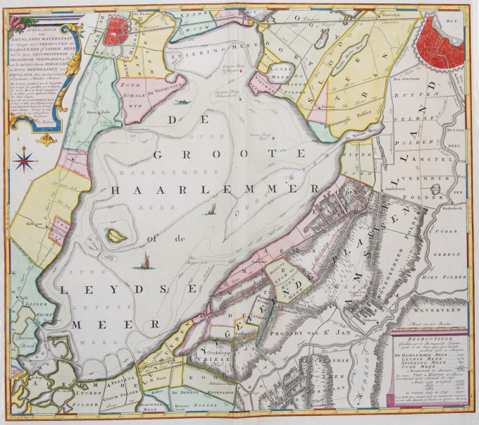
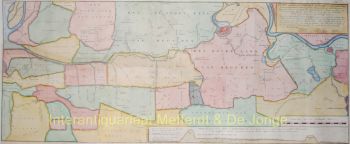
- About the artworkDE NIEUWE HAARLEMMERMEER, HET GROOTSTE MEER VAN HOLLAND "Afbeeldinge van Rhynlands Waterstaat ten Opzigte van 't Vergrooten der Haarlemmer of Leydse Meer met de hyrna Gecombineerde en Omleggende Veenplassen"?. Kopergravure vervaardigd door Melchior Bolstra in 1740. Later met de hand gekleurd. Afm. 55 x 63,5 cm. Bolstra, landmeter van Rijnland, verrichtte onderzoek naar de oeverafslag van het Haarlemmermeer in de loop der tijd. Met stippellijnen is de omvang van het meer in vroeger eeuwen weergegeven. Duidelijk is te zien dat het meer eertijds bestond uit een aantal kleine meren die geleidelijk een grote waterplas zijn gaan vormen. Bolstra maakte ook een plan voor de drooglegging van het meer. Plannen voor drooglegging bestonden al sinds de 17e eeuw, maar er bestond sterke oppositie. Zo wilde Leiden zijn lucratieve visrechten niet kwijt en lag Haarlem dwars omdat het fors verdiende aan de scheepvaart. Nadat in 1836 een storm het water opjoeg tot de poorten van Leiden en Amsterdam, besloot koning Willem I dat het meer moest worden droog gemaald. Dat gebeurde uiteindelijk met stoomkracht tussen 1848 en 1852. Prijs: Euro2.150,- (BTW margeregeling)
- About the artist
Melchior Bolstra (Makkum, 1703 or 1704 - Leiden, before November 9, 1779) was a Dutch land surveyor, who was employed by the Hoogheemraadschap van Rijnland for 45 years. He also published a very large number of maps of regions outside the Rhineland.
On October 1, 1731, he was appointed surveyor of the Rijnland Water Board. In addition to his cartographic work, he was an experienced hydraulic engineer who made many accurate river and lake maps, such as of the Haarlemmermeer and Leidse Meer. became.
In 1742, the land surveyor Bolstra and the overseers Nicolaus Cruquius and Jan Noppen were commissioned by their employer, the board of the Hoogheemraadschap, to investigate a possible reclamation of the Haarlemmermeer. They recommended the construction of a wide ring canal and drainage by 112 windmills, supplemented by an outlet on the North Sea near Katwijk. The total costs of this proposal would amount to approximately 7 million guilders.
In 1774, they received a follow-up assignment, which was mainly aimed at further combating bank erosion. Ultimately, this lake would only be drained more than a century later, with the help of 3 steam pumping stations.In 1766 he and Frederik Beijerinck were commissioned to do a study of the mouth of the Pannerdens Kanaal. In the years that followed, he made the necessary maps of this area to get an idea of the many shallows. This led to a proposal for deepening works, but these were not carried out because the tenders were too far above the estimates.
In 1772, Bolstra worked with Christiaan Brunings and Jacob Engelman on a study to combat the silting up of the IJ near Amsterdam. This also led to a plan in 1773 that was not implemented because of the high costs.
On November 9, 1776, Klaas Vis was appointed as successor at Rijnland to Bolstra, who had died shortly before that moment.
Are you interested in buying this artwork?
Artwork details
Related artworks
- 1 - 1 / 1
Cornelis Anthonisz Theunissen
SEHR SELTENE ERSTE GEDRUCKTE KARTE VON AMSTERDAM, EINER STADT AUF DEM AUFSTIEG1544
€ 175.000Inter-Antiquariaat Mefferdt & De Jonge
 Kuratiert von
Danny Bree
1 - 4 / 24Cornelis Anthonisz Theunissen
SEHR SELTENE ERSTE GEDRUCKTE KARTE VON AMSTERDAM, EINER STADT AUF DEM AUFSTIEG1544
€ 175.000Inter-Antiquariaat Mefferdt & De Jonge
 Kuratiert von
Danny Bree
1 - 4 / 12

