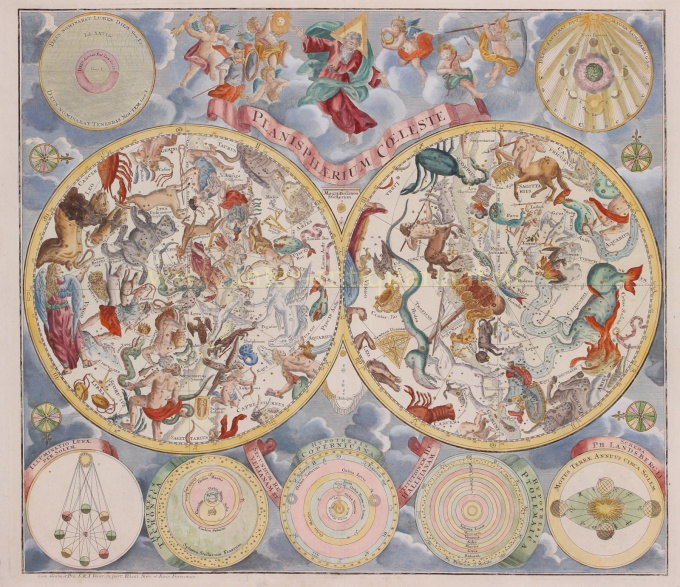
Celestial chart 1750
Matthias Seutter
PapelImpresión
48 ⨯ 57 cm
€ 1.950
Inter-Antiquariaat Mefferdt & De Jonge
- Sobre la obra de artePlanisphaerium Coeleste. Copper engraving published by Matthäus Seutter in Nuremberg around 1750. Coloured by a leter hand. Size: 48 x 57 cm. This chart shows us the stars of the Northern and Southern Hemispheres depicted as allegorical figures, animals and scientific instruments. The style of the constellations follows the Firmamentum Sobiescianum sive Uranographia from 1687 by the Polish astronomer Johannes Hevelius. The chart's design was based on work by the Nuremberg astronomer Georg Christoph Eimmart (1638-1705). In addition to the hemispheres, we see seven diagrams against a background of clouds. At the top left texts from Genesis: God called the light "day", and the darkness He called "night". At the top right the phases of the moon as seen from earth. In the center at the top we see God as the Creator, seated on a cloud and accompanied by putti. At the bottom left: the illumination of the moon by the sun, astronomical models by Tycho Brahe, Copernicus and Ptolemy as well as a model by Van Lansberge about the movement of the earth around the sun. A key to the size of the stars on the hemispheres is shown in the center. Price: Euro 1.950,-
- Sobre el artista
Matthias Shutter nació en 1678 en Alemania. Fue uno de los editores de mapas alemanes más importantes y prolíficos del siglo XVIII. Seutter comenzó su carrera como aprendiz de cervecero. Aparentemente no inspirado por el negocio de la cerveza, Seutter dejó su aprendizaje y se mudó a Nuremberg, donde fue aprendiz de grabador bajo la tutela del prominente J. B. Homann. En algún momento de principios del siglo XVIII, Seutter dejó Homann para establecer su propia empresa editorial cartográfica independiente en Augsburgo. Aunque luchó en los primeros años de su independencia, la habilidad de grabado de Seutter y su compromiso con la producción diversificada de mapas finalmente le valieron una gran cantidad de seguidores. La mayoría de los mapas de Seutter se basaban en gran medida, si no en copias, de trabajos anteriores realizados por las firmas Homann y Delisle. En 1732, Seutter era uno de los editores más prolíficos de su tiempo y fue honrado por el emperador alemán Carlos VI con el título de "Geógrafo Imperial". Seutter continuó publicando hasta su muerte, en el apogeo de su carrera, en 1757. La firma Seutter continuó bajo el hijo derrochador de Seutter, Albrecht Carl, hasta su muerte en 1762. Tras la muerte de Albrecht, la firma se dividió entre la firma Probst establecida y la emergente firma de Tobias Conrad Lotter. Lotter, yerno de Matthäus Seutter, era un maestro grabador y trabajaba para la firma Seutter. Seutter murió en 1757.
¿Está interesado en comprar esta obra de arte?
Artwork details
Related artworks
- 1 - 4 / 24
- 1 - 4 / 24
Rene Rietmeyer
"Netherlands, Amsterdam, March 2002"2001
Precio a consultarEuropean Cultural Centre Collection
1 - 4 / 24- 1 - 4 / 12

