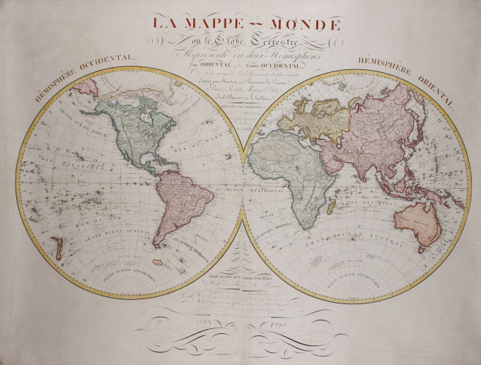
Mapa de parede do mundo 1825
Eustache Hérison
€ 3.250
Inter-Antiquariaat Mefferdt & De Jonge
- Sobre arteWALL MAP OF THE WORLD MAP FROM THE AGE OF DISCOVERY "La Mappe Monde ou le Globe Terrestre Représenté en deux Hémisphères, l'un Oriental, l'autre Occidental, où sont marquées Les Découvertes les plus récentes Faites par Mackenzie, Vancouver, La Pérouse, Bruce, Renell, Mungo-Park, Joub Barrow et Le Vaillant". Double-hemisphere wall map of the world, copper engraving on 2 joined leaves, by Eustache Hérisson. Revised edition published in Paris by Basset, 1825. Size: 90 x 119 cm. (hemispheres each Ø 60,5 cm). Coloured by a later hand. Very rare world map, precisely engraved and filled with finely rendered detail in the interior and along coastlines. The map includes the latest information from the discoveries of Captain Cook, who's three voyages are chronicled. This revised edition is an update of earlier and smaller editions of the map (the first being issued in 1795) with the most recent discoveries added. The explorers Lapérouse, Alexander Mackenzie, George Vancouver, James Bruce, James Renell, Mungo Park, John Barrow and François Le Vaillant are mentioned in the caption and their respective voyages indicated on the map. About the explorers: James Cook (1728-1779) joined the British merchant navy as a teenager and joined the Royal Navy in 1755. He saw action in the Seven Years' War, and subsequently surveyed and mapped much of the entrance to the Saint Lawrence River during the siege of Quebec. This helped bring Cook to the attention of the Admiralty and Royal Society. This notice came at a crucial moment in both Cook's career and the direction of British overseas exploration, and led to his commission in 1766 as commander of HMS Endeavour for the first of three Pacific voyages. On his voyages to the Pacific Captain Cook achieved the first recorded European contact with the eastern coastline of Australia and the Hawaiian Islands, and the first recorded circumnavigation of New Zealand. In three voyages Cook sailed thousands of miles across largely uncharted areas of the globe. He mapped lands from New Zealand to Hawaii in the Pacific Ocean in greater detail and on a scale not previously achieved. As he progressed on his voyages of discovery he surveyed and named features, and recorded islands and coastlines on European maps for the first time. He displayed a combination of seamanship, superior surveying and cartographic skills, physical courage and an ability to lead men in adverse conditions. Compte Lapérouse (1741 - 1788?) was appointed in 1785 by Louis XVI to lead an expedition around the world. The expedition's aims were to complete the Pacific discoveries of James Cook, correct and complete maps of the area, establish trade contacts, open new maritime routes and enrich French science and scientific collections. His ships were the Astrolabe and the Boussole. They were to explore both the north and south Pacific, including the coasts of the Far East and of Australia, and send back reports through existing European outposts in the Pacific. Alexander Mackenzie (1764 - 1820) was a Scottish explorer known for his overland crossing of what is now Canada to reach the Pacific Ocean in 1793. Captain George Vancouver (1757 -1798) was an English officer of the Royal Navy, best known for his 1791-95 expedition, which explored and charted North America's northwestern Pacific Coast regions, including the coasts of contemporary Alaska, British Columbia, Washington and Oregon. He also explored the Hawaiian Islands and the southwest coast of Australia. James Bruce (1730 - 1794) was a Scottish traveller and travel writer who spent more than a dozen years in North Africa and Ethiopia, where he traced the origins of the Blue Nile. James Rennell (1742 -1830) was the leading British geographer of his time. Rennell constructed the first nearly accurate map of India. Todays he is known as the 'Father of Indian Geography'. Mungo Park (1771 - 1806) was a Scottish explorer of the African continent. He was the first Westerner known to have travelled to the central portion of the Niger River. John Barrow (1764-1848) was an English statesman and one of the greatest promoters of British exploration. Most notably were his expeditions to West Africa and the North Polar Region with attempts to find a Northwest Passage from east to west through the Canadian Arctic. François Le Vaillant (1753 -1824) was a French author, explorer, naturalist, zoological collector, noted ornithologist, and traveller of Africa. Price: Euro3.250,-
Você está interessado em comprar esta obra de arte?
Artwork details
Categoria
Related artworks
Artista Desconhecido
A large wall map of Asia by Nicolas de Fer 1647 - 1720
Preço em pedidoZebregs & Röell - Fine Art - Antiques
1 - 4 / 24- 1 - 4 / 12

