Sumatra 1657
Johannes Janssonius
€ 850
Inter-Antiquariaat Mefferdt & De Jonge
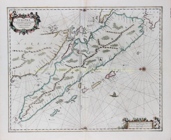
- About the artworkFINE CHART OF SUMATRA AND THE SOUTHERN COASTS OF MALAYSIA. “Sumatrae et Insularum Locorumque Nonnullorum Circumiacentium Tabula Nova.” Copper engraving published by Johannes Janssonius (Jan Jansson) of Amsterdam in 1657 as part of his Atlas Novus. With original hand colouring. Size: 49 x 58 cm. North is orientated to the left of the page. Singapore is probably identified just to the south of Ihor (Johor Bahru) as Senasur. As the map appeared in an atlas of sea charts, little interior detail is given but the coastlines, settlements and principal coastal features are identified. It is one of the earliest detailed depictions of Sumatra and remained the most important map of the region until well into the eighteenth century. A sailing ship and two cartouches embellish the chart: a title cartouche with three allegorical figures and a mileage scale with two surveying putti. In earlier times, Sumatra had been mistaken for the Island of Sri Lanka or Taprobana. The name Taprobana, had been applied to maps of Sumatra from the fifteenth century, after a misunderstanding by the Italian traveller Nicolo de Conti. De Conti dismissed the idea that Sri Lanka was Taprobana and so identified Sumatra as the mythical island described by geographers as Eratosthenes, Strabo, Pliny, Claudius Ptolemy and Cosmas. Price: €850,-
- About the artist
Janssonius was born in Arnhem as the son of Jan Jansz, a printer and publisher there. At a young age he moved to Amsterdam, the then center of the printing and card trade. In 1612 he married Elisabeth Hondius, daughter of Jodocus Hondius. Elisabeth died in 1627 and Janssonius remarried in 1629 with Elisabeth Carlier. He went to work for his father-in-law and continued the publishing business together with Henricus Hondius (son of) after his death. This was developed into one of the largest of its time. There were branches in Berlin, Frankfurt, Geneva, Lyon and Stockholm, among others.
Under Janssonius' leadership, the Mercator-Hondius Atlas was expanded and published as Atlas Novus. This initially one-volume edition soon became a multi-volume atlas, supplemented on request with nautical charts and/or celestial charts. There were publications in Dutch, French, Spanish and Latin. Like his contemporaries, Janssonius also made use of existing copper plates, including those from the city books of Braun & Hogenberg and the Description de touts les Pays Bas (Description of all the Netherlands) by Lodovico Guicciardini - (Cornelis Claesz. edition) from 1609 Although Janssonius has often been accused of copying Willem Blaeu's work, it may be noted that maps by Janssonius also appeared on the market earlier.
After Janssonius' death, the firm was continued by his son-in-law, Johannes (Jan) van Waesbergen, who was married to his daughter Elisabeth Janssonius (1615-1681). Many copper plates of the city books were used (sometimes slightly modified) by Frederik de Wit. The building on Dam Square was leased to Gerard Valck; He also bought a number of printing plates in 1694.
Are you interested in buying this artwork?
Artwork details
Related artworks
- 1 - 4 / 4
- 1 - 4 / 24
- 1 - 4 / 12

