North Holland - Johannes Dou, 1729 by Johannes Dou
Scroll to zoom, click for slideshow

North Holland - Johannes Dou, 1729 1729

Johannes Dou

PapierAfdrukken
86 ⨯ 112 cm
€ 3.250

Inter-Antiquariaat Mefferdt & De Jonge

  • Over kunstwerk
    WALL MAP OF NORTH HOLLAND “’T Hoogheemraadschap vande Uytwaterende Sluysen in Kennemerlant ende West-Frieslant” [The Hoogheemraadschap (water board) of Uitwaterende Sluizen in Kennemerland and West Friesland], copper engraving after the design of Johannes Dou I, published in Amsterdam by Andries and Hendrik de Leth in 1729. Coloured by a later hand. Four sheets joined. Size: 86 × 112 cm. This map is a characteristic example of Dutch water management cartography. To protect the low-lying Holland polderland — situated in a deep basin — from the waters of the sea and rivers, a large number of waterschappen (water boards) were established throughout western Netherlands, each responsible for hydraulic works and flood protection within its district. For efficient water management, accurate overview maps were of vital importance. The Dijkgraaf (dike reeve) and High Heemraden (board members) of the water board of the Uitwaterende Sluizen in Kennemerland and West Friesland commissioned the surveyor and mapmaker Johannes Dou I (1615–1682) to chart their jurisdiction in the northern part of Holland. Dou spent an astonishing twenty years on the project, completing in 1682 an enormous map composed of sixteen sheets. Two years later, a reduced version on four sheets was produced, as well as a smaller single-sheet edition. All three versions of the map were engraved by Koenraet Decker (1651–1709), a pupil of Romeyn de Hooghe and Abraham Deur. Although their names appear only on the sixteen-sheet edition, it has been shown that the copperplates were reused and copied multiple times, both individually and in sets of three maps. While the cartographic content remained unchanged, small variations can be found in the coats of arms of the water board officials. Based on the heraldry on this particular copy — those of Dijkgraaf Aris van der Mienden, and Hoogheemraden Gijsbert Ramp, Claas Swaan, Cornelis van Eyck, Adriaan Warmenhuisen, and Rentmeester en Secretaris (land agent and secretary) Johan Baert — we can date this example to 1729. Johannes Dou I was admitted as a land surveyor by the Hof van Holland (High Court of Holland) on 10 September 1635. He studied at the University of Leiden, and after his father’s death in 1635 he was appointed, together with Steven van Broeckhuysen, as permanent surveyor of the Hoogheemraadschap van Rijnland. From 1637 onwards he also practised as a notary public. Literature: o.a. Donkersloot - de Vrij, Topografische kaarten van Nederland vóór 1750, p. 147-148, no. 751. Price: Euro 3.250,-
  • Over kunstenaar

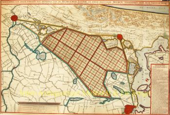
    Johannes Dou, ook wel Jan Jansz., of Douw (Leiden, 7 februari 1615 - 5 maart 1682) was een landmeter die vooral gewerkt heeft voor het Hoogheemraadschap van Rijnland.

    Johannes Dou werd in 1615 (volgens zijn vader op 7 februari) geboren in Leiden als zoon van Jan Pieterszoon Dou en Josina Sadelaer. Johannes werd op 8 maart 1634 bij de universiteit van Leiden ingeschreven als student mathematica.

    Hij volgde colleges bij Frans van Schoten sr., hoogleraar in de 'Duytsche mathematicque', de opleiding voor ingenieurs, vestingbouwers en landmeters. Zijn vader was een vooraanstaand landmeter met een grote productie, die bovendien diverse boeken publiceerde over zijn vakgebied.

    Waarschijnlijk heeft hij zijn zoon in de praktijk het nodige bijgebracht. In ieder geval werd Johannes op 10 september 1635 door het Hof van Holland toegelaten het beroep van landmeter uit te oefenen. In 1637 werd hij benoemd tot notaris.

    Na het overlijden van zijn vader in 1635 werd Dou samen met Steven van Broeckhuizen aangesteld als landmeter van Rijnland en komt vanaf 1637 ook voor als notaris te Leiden. Net als zijn vader was hij bijzonder productief, maar hij verwierf nooit diens wetenschappelijke statuur.

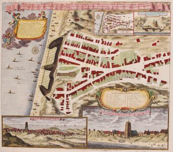
    Naast vele kleine opdrachten onderscheidde hij zich ook met enkele smaakmakender werken. Zo ontwierp hij in 1661 de trekvaart van Leiden naar Utrecht, werd hij in 1672 ingezet tijdens de veldtocht tegen de Fransen en voltooide hij in 1675 zijn groote kaart van de Uitwaterende Sluizen.

Bent u geïnteresseerd om dit kunstwerk te kopen?

Artwork details