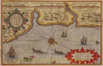
WIND ROSE BY JANSSON, ONE OF THE EARLIEST ANEMOGRAPHIC CHARTS "Tabula Anemographica seu Pyxis Nautica Ventorum nomina sex linguis repraesentans" [Anemographic charts or nautical wind compass representing the names of the winds in six languages], copper engraving published by Johannes Janssonius (a.k.a. Jan Jansson) in 1650 as part of his "Groote Atlas, vervattende de Water-Weereld" [gand atlas, including the water world]. Coloured by a later hand. Size: 43.5 x 54.5 cm. "This chart depicts the sea compass with the magnetic needle, which sailors use on the wild and raging sea, where one sees nothing but sky and water and has no given path before them, and thus determine their true course and may find the places where they wish to sail." This chart was made during a time when directional observation was changing, a time when transitioning from a wind rose to a compass rose. In ancient Greece - before the invention of the magnetic compass - sailors defined directions based on the different winds and where they came from. Homer spoke of four main wind directions, but as navigation and cartography developed further, more directions were added. Names for wind directions were named after gods, constellations of stars, or weather conditions in Greek, Latin, and other languages. The use of different names for the same wind directions made it even more confusing. This "Table of Winds" provided a solution. On a 360° compass, 32 wind directions are indicated with names in Dutch, French, Italian, Latin, and Greek. Each wind is represented by a blowing figure with the characteristics of the people from the area where the wind was associated. The main wind directions are depicted larger. The top left quadrant represents the north: bearded Germanic or Scandinavian types. Top right are the winds from the east: beardless, dark men. The smooth faces from the south and west are less easily identifiable but probably represent the Greeks and indigenous inhabitants of America. So-called anemographic charts like this were functional and used as references. Sea charts already existed in the 17th century, but much use was made of sailors' guides in which (as text) it might say, for example, "follow the southwest wind for three days," then "go with the east wind." A seafarer could consult a chart like this to determine the sailing direction. Price: Euro 2.250,- (incl. frame)