Southeast Asia 1745
Joachim Ottens
PapierImprimer
77 ⨯ 55 cm
€ 1.850
Inter-Antiquariaat Mefferdt & De Jonge
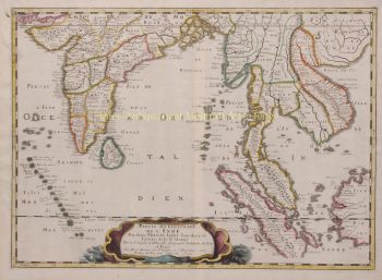
- Sur l'oeuvre d'artONE OF THE MOST BEAUTIFUL MAPS OF SOUTHEAST ASIA EVER PRINTED “Le Royaume de Siam Avec les Royaumes qui luy sont Tributaires et les Isles de Sumatra, Andemaon, etc.” Copper engraving on two joined sheets made by Joachim Ottens and published by his sons Reinier and Josua, around 1745. With original hand colouring. Blank on verso. Size (platemark): 77 x 55 cm. This very fine large map covers much of Southeast Asia and the East Indies, including modern day Thailand, southern Vietnam, Cambodia, Malaysia, Singapore, Borneo, Sumatra and Java. This remarkable map was one of the largest and most detailed maps of this region to appear in the early 18th century. It was drawn by Joachim Ottens and published by his sons as part of their composite atlas. The Dutch, French, and English trading companies were all operating in the region at the turn of the 17th to 18th century with the Kingdom of Siam in a key role at the center of trade. There is good detail along the navigable inland river systems, particularly the Mekong and the Chao Phraya. In the Kingdom of Siam, the map shows the fortress of Bangkok, the ancient Siamese capital of Ayutthaya, royal palace, and the Dutch trading colony. In Cambodia, it details the villages of Ponompingn (Phnom Penh), Longvek, and again the Dutch trading mission. Between Cambodia and Cochinchina (Vietnam) there is mention of “Peuples Barbares” living in the mountains. The lower part of the map details the southern parts of the Malay Peninsula with Malacca “which the Dutch took from the Portuguese in 1640”, Sumatra, Borneo and Java. It mentions the “Estrecho de Cigapura” and shows the island that would fatefully be settled in 1819 by Sir Thomas Stamford Raffles. The map offers superb detail along the coasts naming numerous forts, trade missions, settlements and islands. It also shows the Jesuit routes between from the Sunda Strait via Batavia (Jakarta) to Siam. Joachim Ottens (1663 - 1719) and his sons Reinier (? - 1750) and Josua (? - 1765) Ottens were prominent Dutch booksellers and map publishers from about 1680 to 1790. Joachim, the founder of the firm, was initially employed as a copperplate engraver by Frederick de Wit. In 1711 Joachim founded his own firm. Though Joachim died only a few years later, his sons Renier and Joshua took over the firm and presided over its most prolific period. The Ottens family's most notable contribution to cartography were its enormous made-to-order multi-volume atlases such as the Atlas Major. Some examples of the Atlas are compiled from over 800 separately issued maps. Price: Euro 1.850,-
- Sur l'artiste
Joachim Ottens (1663 - 1719) et ses fils Renier (1698 - 1750) et Joshua (? - 1765) étaient d'éminents libraires et éditeurs de cartes hollandais.
La période de 1630 à 1700 fut « l'âge d'or » de la cartographie hollandaise. Les cartes étaient perçues comme des œuvres d'art, le travail manuel était très apprécié, la gravure était au plus haut niveau, mais du point de vue de la précision géographique, les cartes des maîtres néerlandais étaient inférieures aux cartes produites en Allemagne, en France et dans d'autres pays européens. .
Joachim, le fondateur de la firme Ottens, est né à Amsterdam et a d'abord travaillé comme graveur sur cuivre. En 1711, il fonde sa propre entreprise spécialisée dans l'édition et l'impression, vendant des livres, des cartes, des cartes postales et les illustrant.
Bien que Joachim décède quelques années plus tard, ses fils, Renier et Joshua, poursuivent avec succès l'entreprise paternelle. La contribution la plus significative à la cartographie de la famille Ottens a été les énormes atlas en plusieurs volumes qu'ils ont réalisés sur commande, comme Atlas Major. Certains numéros d'Atlas sont composés de plus de 800 cartes publiées séparément.
Êtes-vous intéressé par l'achat de cette oeuvre?
Artwork details
Related artworks
- 1 - 2 / 2
Artiste Inconnu
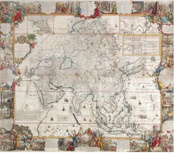
A large wall map of Asia by Nicolas de Fer 1647 - 1720
Prix sur demandeZebregs & Röell - Fine Art - Antiques
1 - 4 / 24Artiste Inconnu
A large wall map of Asia by Nicolas de Fer 1647 - 1720
Prix sur demandeZebregs & Röell - Fine Art - Antiques
1 - 4 / 12- 1 - 4 / 24
- 1 - 4 / 12


