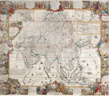
Asia - Jan Jansson, 1638-1642 1638 - 1642
Johannes Janssonius
Papier
45 ⨯ 56 cm
€ 3.450
Inter-Antiquariaat Mefferdt & De Jonge
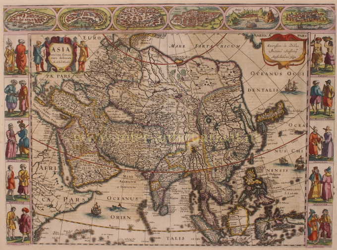
- Sur l'oeuvre d'artFINE RARE CARTE À FIGURES MAP OF ASIA "Asia recens summa cura delineata Auct. Iud: Hondio". Copper engraving by Jodocus Hondius, published in Amsterdam between 1638-1642 (4th state) by Jan Jansson. With original hand colouring. Verso: German text. Size: 45,5 x 56,5 cm. This highly attractive map embraces all of Asia. The Middle East is very well formed, although the Caspian Sea has the egg-like form it maintained on maps until the 1730s. The Arabian Peninsula is well defined, based on Portuguese sources, and India takes its form after the maps of the Dutch adventurer, Jan Huygen van Linschoten (1596), which, in turn, borrowed from Portuguese sources. Southeast Asia and the Indonesian Archipelago are derived from charts made for the Dutch East India Company (VOC), while China is derived from Jesuit sources, although Korea is an oddly elongated peninsula. The geography of the region would remain an enigma to Europeans until the early 18th Century. Japan's Honshu and Kyushu are recognizable, although the area further to the northeast remains a vast mystery. True to the carte à figures' style, which was the hallmark of the great contemporary period of Dutch Baroque cartography, the map is surrounded on four sides by registers of fine vignettes. Along the top of the map are views of Famagusta (Cyprus), Rhodes (Greece), Damascus, Jerusalem, Aden and Hormuz (Persia). Along the left side of the map are depictions of people in local costume including Syrians, Arabs, Armenians & Persians, Indians, and Sumatrans. On the right side are depictions that include Javanese, Moluccans & Bandans, Chinese, Russians and Tartars. Along the bottom of the map there are further town views of Dutch trading posts Goa (India), Calcutta (Bengal/India), Kandy (Ceylon), Bantam, Gammalamme (Moluccas) and Macao. In addition the map is embellished by a fine title cartouche and ships and sea monsters in the seas. The map was originally conceived by Jodocus Hondius the Younger (1594-1629), whose eponymous father played a large part in the rise of Amsterdam as the dominant cartographic production centre in the 17th Century. The present edition of the map is by Jan Jansson (1588-1664), who married Jodocus the Younger's sister Elizabeth. He transformed the Hondius firm into a powerhouse of geographical publications. Jansson most notably published the Atlas Novus (1638), and the Atlas Major (1660), the 11 volumes of which included a town atlas, a hydrographic atlas, an atlas of the ancient world, and Andreas Cellarius' incomparable celestial atlas. Jansson's works were rivalled only by those of his arch-nemesis Joan Blaeu. The present map is one of the finest depictions of Asia from the apogee of Dutch cartography. Price: Euro 3.450,-
- Sur l'artiste
Janssonius est né à Arnhem en tant que fils de Jan Jansz, imprimeur et éditeur là-bas. Très jeune, il s'installe à Amsterdam, alors centre de l'imprimerie et du commerce de cartes. En 1612, il épousa Elisabeth Hondius, fille de Jodocus Hondius. Elisabeth mourut en 1627 et Janssonius se remaria en 1629 avec Elisabeth Carlier. Il est allé travailler pour son beau-père et a continué l'entreprise d'édition avec Henricus Hondius (fils de) après sa mort. Cela a été développé dans l'un des plus grands de son temps. Il y avait des succursales à Berlin, Francfort, Genève, Lyon et Stockholm, entre autres.
Sous la direction de Janssonius, l'Atlas Mercator-Hondius a été élargi et publié sous le nom d'Atlas Novus. Cette édition initialement en un volume est rapidement devenue un atlas en plusieurs volumes, complété sur demande par des cartes marines et/ou des cartes célestes. Il y avait des publications en néerlandais, français, espagnol et latin. Tout comme ses contemporains, Janssonius a également utilisé des plaques de cuivre existantes, notamment celles des livres de ville de Braun & Hogenberg et la Description de touts les Pays Bas (Description de tous les Pays-Bas) de Lodovico Guicciardini - (édition Cornelis Claesz.) de 1609 Bien que Janssonius ait souvent été accusé de copier l'œuvre de Willem Blaeu, on peut noter que des cartes de Janssonius sont également apparues sur le marché plus tôt.
Après la mort de Janssonius, l'entreprise a été poursuivie par son gendre, Johannes (Jan) van Waesbergen, qui était marié à sa fille Elisabeth Janssonius (1615-1681). De nombreuses plaques de cuivre des livres de la ville ont été utilisées (parfois légèrement modifiées) par Frederik de Wit. Le bâtiment de la place du Dam a été loué à Gérard Valck ; Il a également acheté un certain nombre de plaques d'impression en 1694.
Êtes-vous intéressé par l'achat de cette oeuvre?
Artwork details
Related artworks
- 1 - 4 / 4
- 1 - 4 / 24
Artiste Inconnu
A large wall map of Asia by Nicolas de Fer 1647 - 1720
Prix sur demandeZebregs & Röell - Fine Art - Antiques
1 - 4 / 12- 1 - 4 / 24
- 1 - 4 / 12

