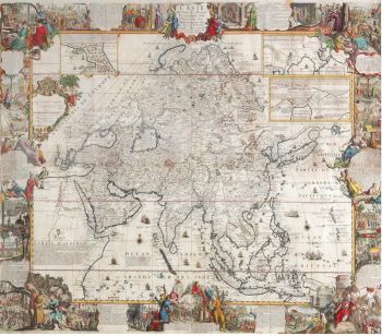
Asia - Jan Jansson, 1638-1642 1638 - 1642
Johannes Janssonius
Papier
45 ⨯ 56 cm
€ 3.450
Inter-Antiquariaat Mefferdt & De Jonge
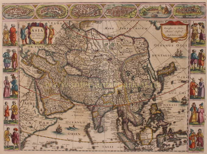
- Over kunstwerkFINE RARE CARTE À FIGURES MAP OF ASIA "Asia recens summa cura delineata Auct. Iud: Hondio". Copper engraving by Jodocus Hondius, published in Amsterdam between 1638-1642 (4th state) by Jan Jansson. With original hand colouring. Verso: German text. Size: 45,5 x 56,5 cm. This highly attractive map embraces all of Asia. The Middle East is very well formed, although the Caspian Sea has the egg-like form it maintained on maps until the 1730s. The Arabian Peninsula is well defined, based on Portuguese sources, and India takes its form after the maps of the Dutch adventurer, Jan Huygen van Linschoten (1596), which, in turn, borrowed from Portuguese sources. Southeast Asia and the Indonesian Archipelago are derived from charts made for the Dutch East India Company (VOC), while China is derived from Jesuit sources, although Korea is an oddly elongated peninsula. The geography of the region would remain an enigma to Europeans until the early 18th Century. Japan's Honshu and Kyushu are recognizable, although the area further to the northeast remains a vast mystery. True to the carte à figures' style, which was the hallmark of the great contemporary period of Dutch Baroque cartography, the map is surrounded on four sides by registers of fine vignettes. Along the top of the map are views of Famagusta (Cyprus), Rhodes (Greece), Damascus, Jerusalem, Aden and Hormuz (Persia). Along the left side of the map are depictions of people in local costume including Syrians, Arabs, Armenians & Persians, Indians, and Sumatrans. On the right side are depictions that include Javanese, Moluccans & Bandans, Chinese, Russians and Tartars. Along the bottom of the map there are further town views of Dutch trading posts Goa (India), Calcutta (Bengal/India), Kandy (Ceylon), Bantam, Gammalamme (Moluccas) and Macao. In addition the map is embellished by a fine title cartouche and ships and sea monsters in the seas. The map was originally conceived by Jodocus Hondius the Younger (1594-1629), whose eponymous father played a large part in the rise of Amsterdam as the dominant cartographic production centre in the 17th Century. The present edition of the map is by Jan Jansson (1588-1664), who married Jodocus the Younger's sister Elizabeth. He transformed the Hondius firm into a powerhouse of geographical publications. Jansson most notably published the Atlas Novus (1638), and the Atlas Major (1660), the 11 volumes of which included a town atlas, a hydrographic atlas, an atlas of the ancient world, and Andreas Cellarius' incomparable celestial atlas. Jansson's works were rivalled only by those of his arch-nemesis Joan Blaeu. The present map is one of the finest depictions of Asia from the apogee of Dutch cartography. Price: Euro 3.450,-
- Over kunstenaar
Janssonius werd geboren in Arnhem als zoon van Jan Jansz, een drukker en uitgever aldaar. Op jonge leeftijd verhuisde hij naar Amsterdam, het toenmalige centrum van de boekdrukkunst- en kaartenhandel. In 1612 trouwde hij met Elisabeth Hondius, dochter van Jodocus Hondius. Elisabeth overleed in 1627 en Janssonius hertrouwde in 1629 met Elisabeth Carlier. Hij ging werken voor zijn schoonvader en zette na diens dood samen met Henricus Hondius (zoon van) de uitgeverij voort. Deze werd uitgebouwd tot een der grootste van die tijd. Er waren vestigingen in onder andere Berlijn, Frankfort, Genève, Lyon en Stockholm.
Onder Janssonius' leiding werd de Mercator-Hondius Atlas uitgebreid en gepubliceerd als Atlas Novus. Deze, aanvankelijk uit één deel bestaande uitgave werd spoedig een uit meerdere delen bestaande atlas, op verzoek aangevuld met zeekaarten en/of hemelkaarten. Er waren uitgaven in het Nederlands, Frans, Spaans en Latijn. Net als zijn tijdgenoten maakte ook Janssonius gebruik van bestaande koperplaten, onder andere uit de stedenboeken van Braun & Hogenberg en de Description de touts les Pays Bas (Beschrijvinghe van alle de Neder-Landen) door Lodovico Guicciardini - (Cornelis Claesz. editie) uit 1609. Alhoewel Janssonius vaak is beschuldigd van het kopiëren van werk van Willem Blaeu mag opgemerkt worden dat er ook kaarten van Janssonius eerder op de markt verschenen.
Na Janssonius' dood werd de firma voortgezet door zijn schoonzoon, Johannes (Jan) van Waesbergen, die gehuwd was met zijn dochter Elisabeth Janssonius (1615-1681). Veel koperplaten van de stedenboeken werden (soms lichtelijk aangepast) gebruikt door Frederik de Wit. Het pand op de Dam werd verhuurd aan Gerard Valck; ook een aantal drukplaten zijn in 1694 door hem opgekocht.
Bent u geïnteresseerd om dit kunstwerk te kopen?
Artwork details
Related artworks
- 1 - 4 / 4
- 1 - 4 / 24
Onbekende Kunstenaar
A large wall map of Asia by Nicolas de Fer 1647 - 1720
Prijs op aanvraagZebregs & Röell - Fine Art - Antiques
1 - 4 / 12Rene Rietmeyer
"Germany, Saarland, April 2001"2001
Prijs op aanvraagEuropean Cultural Centre Collection
1 - 4 / 24- 1 - 4 / 12

