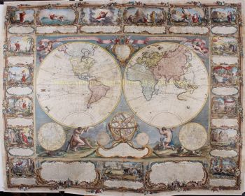
Wereldkaart 1745
Covens and Mortier
€ 2.250
Inter-Antiquariaat Mefferdt & De Jonge
- Over kunstwerkMappe-Monde Dressé sur les Observations de Mrs. De L'Academie Royale des Sciences et quelques autres et sur les memoires les plus recens Par M. De L'Isle. Copper engraving published by Covens & Mortier in Amsterdam 1745. Coloured by a later hand. Size: 50,8 x 63,5 cm. Guillaume De L'Isle's world map was originally published in 1700 and then revised and republished throughout the 18th century by De L'Isle and by subsequent map publishers. Dutch publishers Covens & Mortier's first version of De L'Isle's map was produced in 1720 adding the seascape with ships on the horizon at the bottom decorated with a second cartouche in the shape of a sea monster with a mermaid, merman and dolphins. They issued a later edition of that map (shown here) in about 1745 with the additional subtitle "Nouvellement corrigée apres les dernieres Decouvertes faites par l'Academie de Petersbough." The map consists of two central hemispheres, eastern and western, surrounded by four smaller polar projections. The right hand projections focus on the Northern Hemisphere while the left hand projections depict the Southern. At top center there is an elaborate decorative cartouche with various allegorical elements depicting the four great continents in female form, from top left: America, Europa, Africa, and Asia. The routes of a number of the most famous explorers of the major oceans of the world are shown from 1542 to approximately 1730, ending with the Russian voyages of Chirikov and Bering. Some of the more noteworthy features of the map includes the Russian explorations along the Northwestern coast of America, Aleutian islands shown in a semi-mythical configuration and attached to a highly conjectural Alaska; Edmund Halley's sighting of Antarctic ice; Bouvet's large Cap de la Circoncision; A depiction of the tracks of François Pelsaert's route from Australia to Java; Carpentaria attached to New Guinea; Abel Tasman's route, along with a depiction of Tasmania, distinctly separate from Australia. The map also retains one of the more curious peninsula depictions of California. Price: Euro2.250,-
- Over kunstenaar
Covens en Mortier (1721 - ca. 1862) was een Amsterdamse uitgeverij, de opvolger van het omvangrijke uitgeverij-imperium dat door Pierre Mortier (1661 - 1711) was opgebouwd.
De kaart van Covens en Mortier wordt vaak bekritiseerd als afgeleide, maar dit is niet helemaal het geval. Pierre Mortier woonde van 1681 tot 1685 in Parijs. Daar bouwde hij hechte relaties op met de grootste Franse cartografen van die tijd, waaronder De L'Isle en D'Anville.
Zijn bedrijfsmodel was gebaseerd op het benutten van Nederlandse printtechnologie en verfijning om samen de allernieuwste Franse cartografie te publiceren. Na de dood van Mortier in 1711 werd zijn bedrijf overgenomen door zijn zoon, Cornelius Mortier (1699 - 1783). Cornelius trouwde in 1721 met de zus van Johannes Covens (1697 - 1774) en richtte samen met zijn zwager de firma Covens and Mortier op.
Onder de afdruk van Covens en Mortier gingen Cornelius en Johannes door met het model van Pierre om met toestemming de meest actuele Franse werken te publiceren. Ze werden al snel een van de grootste en meest productieve Nederlandse uitgeverijen van de 18e eeuw.
Het bedrijf en zijn opvolgers publiceerden duizenden kaarten over een periode van 120 jaar van 1721 tot het midden van de 19e eeuw. Tijdens hun lange bestaan publiceerde de firma Covens and Mortier als Covens and Mortier (1721 - 1778), J. Covens and Son (1778 - 94) en Mortier, Covens and Son (1794 - ca. 1862).
Bent u geïnteresseerd om dit kunstwerk te kopen?
Artwork details
Related artworks
- 1 - 4 / 7
- 1 - 4 / 24
- 1 - 4 / 12


