British Isles - Willem Blaeu, c. 1645 1645
Willem Janszoon Blaeu
ImprimerGravure
41 ⨯ 52 cm
€ 1.650
Inter-Antiquariaat Mefferdt & De Jonge
- Sur l'oeuvre d'artBLAEU’S HEPTARCHY MAP “Britannia prout divisa fuit temporibus Anglo-Saxonum praesertim durante illorum Heptarchia.” Copper engraving published by Willem Blaeu in Amsterdam c. 1645. Verso text in Latin. With original hand colouring. Size: 41,2 x 52,6 cm. Wonderful map of Anglo-Saxon England flanked by intricately rendered portraits of the kings of the 5th through 7th centuries. The monarchs to the left are those of the pre-Christian era, while those on the right are depicted receiving Christianity or being martyred for its sake. Sebert of Essex can be seen in the second panel down on the right re-consecrating the temples of Apollo and Diane; they would become St. Paul’s Cathedral in London, and St. Peter’s at Westminster. This is often called the Heptarchy Map, as it presents England during the time following the Anglo Saxon conquest of southern England, approximately from 500 to 850 A.D., which is known as the Heptarchy Period. (The word itself refers to the seven kingdoms that would eventually combine to form the Kingdom of England in the 10th century.) The map shows England divided into the seven Saxon kingdoms, each decorated with its coat-of-arms. Scotland, Wales, and part of Ireland are also shown with their arms. The kings are shown with their escutcheons and their forces (townships) named. The vignettes flanking the two sides are identical in subject matter to those used in 1626 on a map by John Speed, but the execution of each is in the style of "an unmistakeable Dutch miniature". Price: Euro 1.650,-
- Sur l'artiste
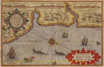
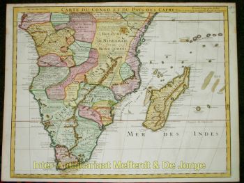
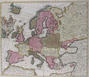
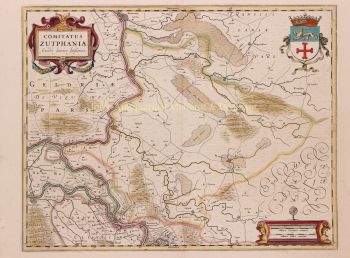
"Willem Janszoon Blaeu et son fils Joan ont incarné "l'âge d'or" de la cartographie néerlandaise. Travaillant au XVIIe siècle, Willem Blaeu a dessiné un certain nombre de cartes révolutionnaires et publié le premier atlas.
Il est né en 1571 à Amsterdam et a d'abord travaillé comme commis dans le commerce familial du hareng. Cependant, il n'était pas satisfait de son occupation et quitta la maison en 1594 pour étudier les mathématiques avec Tycho Brahe, le célèbre astronome. Blaeu était un bon élève qui impressionnait beaucoup son tuteur, et quand ses études furent terminées, il retourna à Amsterdam et s'installa comme cartographe. Son entreprise a prospéré et sa réputation a grandi. Il a été le premier cartographe à produire des cartes à feuille unique de nombreux pays européens.
En 1605, il a fait une carte murale du monde, englobant 20 feuilles, chacune de 8 pieds de diamètre. Cette carte était de loin la plus précise de l'époque et apporta une contribution remarquable à la connaissance de la géographie mondiale.
Sa carte est restée la plus précise jusqu'en 1648, lorsque son fils, Joan, qui est également devenu un célèbre cartographe, l'a mise à jour. Mais sa plus grande réalisation fut la production du premier atlas en 1630. Le nom Blaeu était en fait un surnom de famille que Willem prit après une confusion entre lui et son grand rival Joannes Jansonius.
Êtes-vous intéressé par l'achat de cette oeuvre?
Artwork details
Related artworks
- 1 - 4 / 7
Artiste Inconnu
Baroque Iberian Emerald Earrings, 18th Century Goldwork with 58 Emeralds1750
€ 7.250Adin Fine Antique Jewellery
Sélectionné parDanny Bree
Gobert Denis Chambon/ Jean Janvier, S.G. Longschamps
Magnificient antiek World map1754
€ 17.500Inter-Antiquariaat Mefferdt & De Jonge
Sélectionné parDanny Bree
1 - 4 / 24Gobert Denis Chambon/ Jean Janvier, S.G. Longschamps
Magnificient antiek World map1754
€ 17.500Inter-Antiquariaat Mefferdt & De Jonge
Sélectionné parDanny Bree
1 - 4 / 24- 1 - 4 / 24
- 1 - 4 / 12


![RARE ARMORIAL MAP: LEO BRABANTIAE Lion of the most noble Duchy of Brabant] by Sibertus Waterloos](https://media-3.gallerease.com/images/325cc033-a3b6-495f-9da8-6d06caf29b14/350x350/rare-armorial-map-leo-brabantiae-lion-of-the-most-noble-duchy-of-brabant.jpg)


